The power of OpenStreetMap, part 1: Sightseeing vacations
Some must-have navigation tips for a sightseeing vacation.
Last update:
Time to read: 5 minutes.
Problems with on-foot sightseeing trips
Two years ago I was in Italy with my girlfriend and 60% of our days were spent on foot. It was a particularly hot day when we were walking in Verona and we were short on water almost all day; we had to refill our canteens roughly every two hours.
Fortunately, in that year I was introduced to OpenStreetMap-based navigation apps by a friend (and by that summer I was regularly editing the map around my home). I discovered even before our trip that Google Maps, which is used by many people, does not really favour tourists who want to see the city on foot. There are remarkably few drinking fountains marked in the historic city of Verona, unlike on OpenStreetMap.
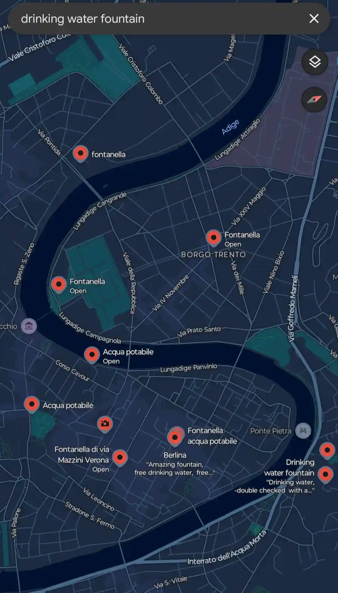
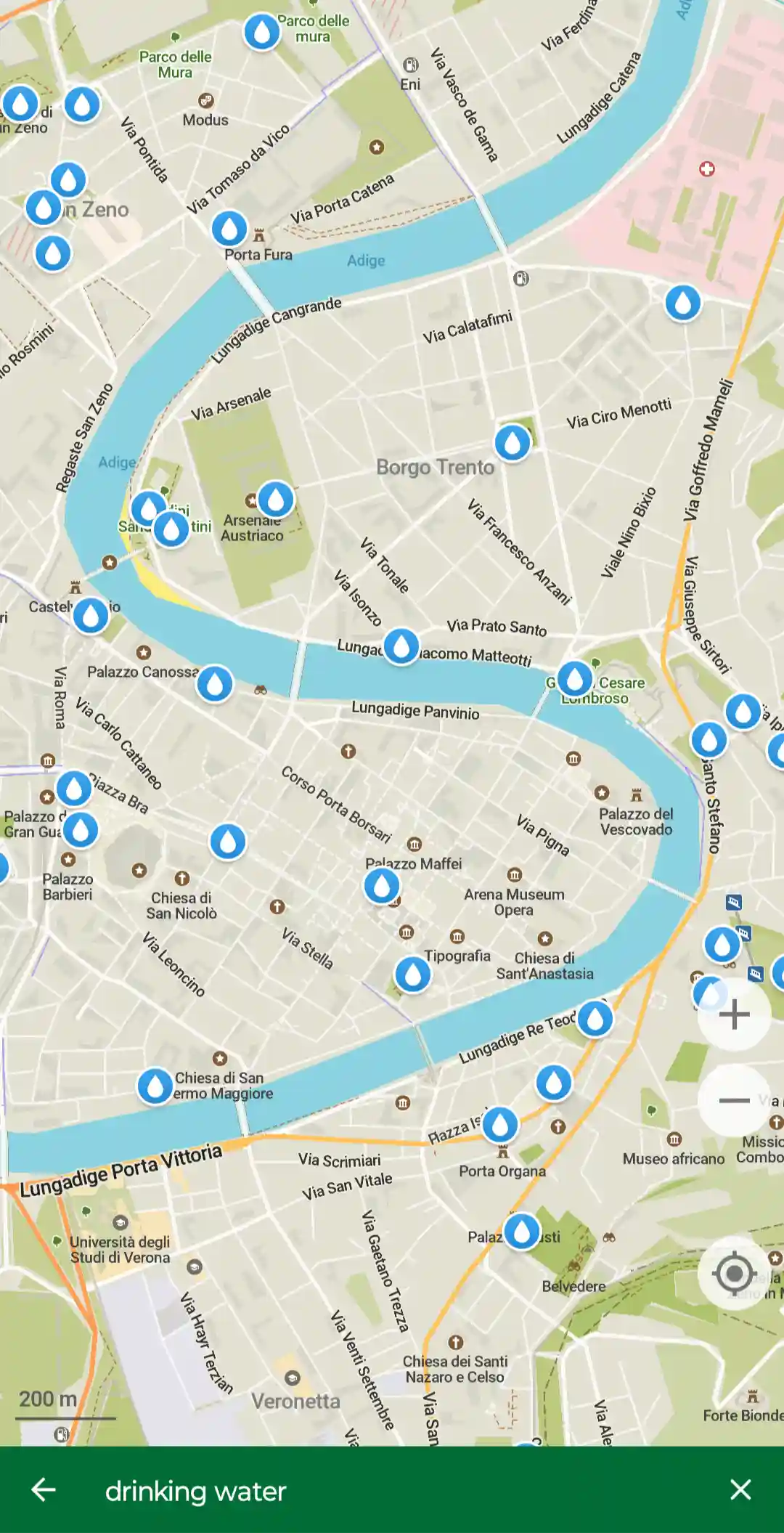
I cannot count how many drinking water fountains were mapped in the heart of Verona on OpenStreetMap compared to the especially small number of only nine on Google Maps.
Another problem was that small passageways that are perfectly walkable on foot are mostly absent from Google Maps. Especially hiking paths deep in the woods. If you want to plan a hike with a friend before you embark, I suggest you use an OpenStreetMap compatible hiking routing website. A list of which can be found here on the Wiki. I just use my country’s map using OSMAnd, the Swiss army knife of OpenStreetMap apps available on Android (and you can get the premium version of the app for free, if you install it from F-Droid).
Surprisingly detailed
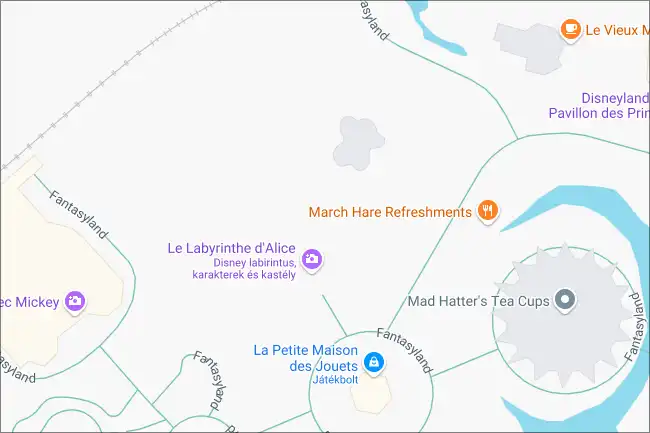
A few days ago, I got home from another sightseeing trip with my girlfriend. This time, we visited Paris, and we spent a whole day in Disneyland® to ride the attractions, see some goofy (hehe) characters and just overall have a fun time. The theme park’s map in the official Disneyland® app was difficult to navigate, as it was basically just a zoomable raster image of the park, that got overlaid with our current position and some markers informing us about the estimated queue lengths of each ride. Not all the walkable roads were on that image, and the navigation function they built into the app was cumbersome to say the least.
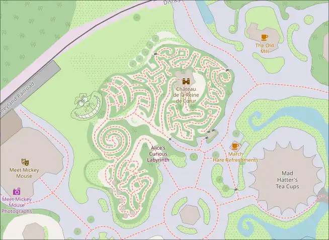
Much to my surprise, checking the previously downloaded map of the area in Organic Maps, another navigation app using OpenStreetMap’s data featuring a clear interface and not-so-much-in-your-face design, I discovered that the theme park we were in was so detailed that it rivaled the official app. The most baffling of all was that some volunteer mappers in the community added all the footpaths present in Alice’s Curious Labyrinth including the flower garden planted in the shape of Cheshire Cat’s face. Where Google Maps shows only a white void (without turning on the satellite view layer), OSM displays the whole length of the labyrinth and the creepy grin on that cat face-shaped flower garden. Needless to say, we did not get lost. :D
You can use it offline
It is also worth mentioning that you can download whole countries’ maps using almost any navigation app based on OpenStreetMap. Both OSMAnd and Organic Maps provide this functionality. This way, you can navigate in rural areas with poor/no cellphone coverage or save on data roaming costs when abroad (does not affect Europeans if they travel within the EU; another W for us, I guess XD).
Note: There’s also another version (fork) of Organic Maps called CoMaps, which I haven’t tried yet, but supposedly has some additional features compared to OM, and it does not nag for donations. May be worth checking out that app too.
The geological database itself that is stored by OSM and is the base of all mapping applications is only around 100 GBs compressed (or 2 TB uncompressed) as of 2025. Of course, this is just the database, so a detailed map using vector graphics should be in the low tens of terabytes. The option is there for you to download the whole map in case the apocalypse comes and you want to be the one that navigates everyone, but keep a large SD card (or rather, a hard drive) at hand. :D
You probably used some apps utilizing OSM
OpenStreetMap data is free to implement into any application / website; you can even print parts of it out using online tools and use it for any purpose like tourist info boards. You only need to acknowledge the fact that you used OSM data. Because of this flexibility in its license terms, many developers prefer it for map-related functionalities. Pokemon Go and Strava being the first projects that come to my mind. You can find more examples here, on the OSM Wiki.
Some drawbacks, use GM and OSM in combination
Circling back to sightseeing trips on foot, the only area where the use of OpenStreetMap was disadvantageous was navigating using public transport lines. The transport lines themselves are usually well mapped by OSM’s volunteers, but the more rapidly changing and intertwined timetables of all the different public transport companies are harder to keep track of. As it is such a massive undertaking for a navigation app project to implement each public transport company’s way of disclosing timetable data, OSM based maps don’t feature as reliable public transport navigation as Google Maps does.
Organic Maps only has a layer for metro/suburban railway lines without timetables. OSMAnd’s public transport navigation also omits timetable data, and the public transport implementation is somewhat crude as of now (not finding a public transport route to e.g. a point 15 kilometers away in a capital city is quite common).
Also, it is variable how detailed OSM is based on the country you’re in. If you frequently search for restaurants or shops in a city, it could be that a place (or Point of Interest, POI) is present on Google Maps, but is unmapped on OpenStreetMap. A volunteer did not add it yet to the map, but this is an opportunity for you to upload the place’s details to OSM once you decide to visit it. It’s like Wikipedia, but for maps.
My rule of thumb is that for an ad-hoc search for nearby restaurants and shops, and for public transport navigation, I use Google Maps. For on-foot navigation once in the heart of a town or a city, and searching for drinking water, I use Organic Maps. For hiking, I use OSMAnd. Sure, juggling around at least two apps while also trying to take in a constant flow of new information that a city you’ve never been in gives sounds and is cumbersome at times, but I’ve also never been on a trip where I did not feel lost for at least a minute even with these tools at my disposal. It’s part of the travelling experience, I guess.
This is just the tip of the OSM-iceberg
One of my all time favorite open IT-projects is OpenStreetMap. As I said earlier, it’s basically Wikipedia, but for maps (technically, it’s a geoinformation database, but map sounds somewhat more friendly). Such a versatile tool for navigating, developing around and for general activities involving any kind of map data. This blog post only scratches the surface of what OSM can be used for. In the next part, I’ll explain how developers can use the map data, why editors like me may want edit the map to keep it up to date (and find a new hobby while they are at it), and show you some of my favourite projects that utilise it.
If you have any comments to add, feel free to share them on the Fediverse: Fedi post on mastodon.grin.hu
See you around!